
A list of Hiking Trails in the Lakes Region of New Hampshire.
Hiking and Biking Trails in New Hampshire’s Lakes Region.
There are many hiking trails throughout the Lakes Region. Hiking and Biking trails both large and small are available for any skill level. The following are the more well-known and accessible trails. Please be sure to dress properly, bring provisions and do not leave litter on the trails or parking areas.
Castle in the Clouds – Moultonborough
Castle in the Clouds Forty-five miles of trails traverse the 5,500 acres of the Castle in the Clouds property, which has been owned and protected since 2002 by the Lakes Region Conservation Trust. This landmark property is part of the Ossipee Mountain ring dike, a circular formation of volcanic origin nine miles in diameter whose impenetrable terrain has discouraged roads and settlement for hundreds of years and has preserved a true wilderness habitat for a wide range of wildlife and vegetation, including several rare and endangered species. Seven of the Ossipee Mountains’ most prominent peaks are on the Castle property, including two of the most popular hiking destinations in the region — Mt. Shaw, the highest at 2,975 feet, with its panoramic view of the White Mountains to the north, and Bald Knob, with its spectacular view of Lake Winnipesaukee to the southwest. The trails, many of which were originally built by Tom Plant as carriage roads, are well maintained, marked, and mapped, with options for every hiking ability. Parking for hikers is available off Route 171 by the information kiosk, just east of the Castle entrance and Severance Road. A picnic area overlooks Shannon Pond, and nature programs are offered on selected afternoons. The Lakes Region Conservation Trust is committed to making the Castle in the Clouds property a resource for everyone’s education and enjoyment. (c) Castle in the Clouds
Belknap Mountain – Gilford
Elevation 740 feet This easy and invigorating climb will bring the hiker to a magnificent view of Lake Winnipesaukee from the top of Belknap Mountain. On a clear day, the Ossipee Mountain range rises from the shores of Winnipesaukee and Mount Washington, often snow capped, can be spotted in the distance. To reach Belknap Mountain, turn off Route 11A at Gilford and drive south through Gilford Village. Stay on this road past the high school (road makes a sharp left turn) and you’ll begin your climb up Belknap Mountain Road. Follow the road up until you see signs and a parking area on the left. Follow the well-marked trails, which begin on the right a few yards along a wooded road. This challenging trail rises steadily and takes the hiker past spruce trees. Eventually, you’ll see the summit a short distance beyond.
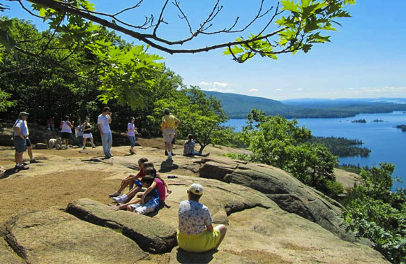
Mount Major – Alton Bay
Mount Major Round-trip time: 2.5hrs / Elevation: 1000 feet With an easy-to-find trail beginning off Route 11 in Alton Bay, this hike is a bit more challenging than Belknap Mountain, and offers equally spectacular views at its summit. Near scenic look-offs of Lake Winnipesaukee on Route 11, about five miles north of Alton Bay a highway sign marks the parking lot for Mount Major. This is a very popular spot, even on a cloudy day, and you’ll know you’ve arrived when you see the many cars spilling from the parking lot during the summer months. Don’t be deterred by the thought that the trails will be crowded. There is room for all. Beginning at a trail in the parking lot, follow the hiking path until it is joined by a logging road. Next you’ll see old stone walls and an old cellar hole. Soon, t trail sign on a tree marks the way and the path grows steeper with ledges. You’ll be rewarded as views of Lake Winnipesaukee are spotted. The ledges, in places, will require some scrambling, so be sure to wear good hiking boots. At the top of Mount Major, a four-sided stone shelter cuts an unusual figure against the sky. The views are spectacular and certainly make the challenging hike worth the effort. You’ll see Alton Bay to the south and Wolfeboro to the north. Rattlesnake Island sits proudly in Lake Winnipesaukee. This is the perfect place to be on a hot day. Due to its elevation, there are always refreshing cool breezes.
Stinson Mountain – Rumney
Stinson Mountain Round-trip distance: 4 miles / Round-trip time: 2.5 hours / Elevation: 1390 feet Many people are unaware that they needn’t travel to the White Mountains for some spectacular hikes. The proof that moderate, enjoyable hikes are closer to the Lakes Region is personified by Stinson Mountain. To reach Stinson, drive west from Plymouth on Route 25 to Rumney. Turn north and drive through the village to Stinson Lake. Bear right near the outlet of the lake and drive uphill. Take a sharp left-hand turn and you’re in the parking lot. An old road is the start of this trail, and should be followed for about 1/4 mil mile where the trail turns left into the woods and borders stone walls and an old cellar hole. If there has been enough rain, a tiny brook near the trail may be water-filled. This trail is winding, and you’ll be rewarded all at once when the trail curves right and suddenly you’re in the clearing with spectacular views of the Baker River Valley, and the Franconia and Sandwich Ranges.
Mount Cardigan – Canaan
Mount Cardigan Round-trip distance: 3 miles / Round-trip time: 2.5 hrs / Elevation: 3121′ This hike is a moderate hike well worth the effort in summer or fall. The trails from the Canaan side are the easiest route to the summit. Reach this trail by traveling to Canaan on Route 4. Turn north on Route 118 and take a right on the road to Orange. Travel straight over a bridge, and then take a right at a fork in the road. This is Grafton Road and you’ll stay on this road for about a mile, when at another fork in the road, you’ll turn left to the entrance for Cardigan State Park. A mile road leads to the parking and picnic areas. The marked West Ridge Trail starts just past the picnic table area and you’ll ascend at an easy pace. You’ll pass two springs, and after these, keep left past the South Ridge Trail to a side climb with outlooks to the right. Soon, you’ll rejoin the West Ridge Trail, and pass the Skyline Trail. Stay on the West Ridge Trail and pass a footbridge, two branch trails, and a shelter area. The route leads to beautiful views of the surrounding area.
Mount Cardigan – Alexandria
Mount Cardigan Round-trip distance: 4.4 miles / Round-trip time: 4 hours / Elevation: 3121′ This is an outstanding peak with excellent views. The trails leading from the Cardigan Mountain Lodge (AMC) in Alexandria range from moderate to difficult. The base area has a wonderful picnic spot, a pond, AMC lodge and camping. Bring a container for wild blueberries in the late spring/summer! Most of the mountain is in a state reservation of over 5000 acres and is adjacent to the AMC’s 1000 acre Cardigan Reservation occupying most of the “Shem Valley”. To reach the trailhead: Follow Route 3A N out of Bristol. 2 miles from Bristol, turn left at the blinking light at the foot of Newfound Lake (West Shore Rd). Follow West Shore Rd a few miles and at the intersection where the “sign tree” is , go straight. (W Shore Rd turns right). Follow this road all the way into Alexandria Village, go through village and take right onto Cardigan Mountain Road. Cardigan Mountain Road is several miles long and intersects with Shem Valley Road which will take you into the Cardigan Lodge trail head.
Rattlesnake Mountain – Rumney
Rattlesnake Mountain Round-trip distance: 1.6 miles / Round-trip time: 1.5 hours / Elevation: 1594′ Want a great view without the all-day hike? Beginning on Buffalo Rd in Rumney this is a moderate trail that offers spectacular views of the Baker River Valley and its surrounding fields and mountains. To get to the trailhead take Route 25W from the Plymouth traffic circle. At blinking light, turn right into Rumney Village. In the village take first left onto Buffalo Rd. 2.5mi west of the village is a small parking area with a historical marker.
Rattlesnake Mountain – Holderness / Sandwich
Rattlesnake Round-trip distance: 1.8 miles / Round-trip time: 1.5 hrs / Elevation: 1260′ If you want the best view of the Squam Lakes, this is your hike. The Old Bridle Path is the easiest route to the rock covered summit and follows an old cart route. Bring your camera, one look won’t be enough! To get to the trailhead, follow Route 113 N from Little Squam in Holderness Village. The parking area is between Center Sandwich and Holderness just after the Rockywold and Deephaven camps. The trail entrance is across from the Mount Morgan Trail. Use the same parking. Look for signs to the “Old Bridle Path” as there is a privately owned trail nearby.
Sugarloaves – Alexandria
Sugarloaf Round-trip distance: 4 miles / Round-trip time: 3 hours With breathtaking views of Newfound Lake, hiking the Sugarloaves is well worth the effort. To reach this hike, take Route 3A from Bristol towards Newfound Lake. Follow the signs to Wellington State Park, located on West Shore Road in Alexandria. Trailhead parking is just past Wellington State Park and is marked “Elwell Trail”. You can also park at Wellington for a small fee. (A word of caution: Wellington, on a typical summer day, is an extremely popular park and beach so come early for good parking.) The Sugarloaves trail begins directly across the road from the park entrance with a sign to the Elwell Trail. The trail is well marked and you’ll hike up hill through large hemlocks and then to a boulder with a yellow marker directing you to turn. After a short distance, you’ll see a sign at a junction marked Goose Pond. Continue straight on past some boulders. At this point, those pretty views of Newfound Lake begin. After climbing a bit more, you’ve reached Little Sugarloaf with wonderful views of Mount Cardigan, Newfound Lake and Big Sugarloaf. Those who are tired can return on the same route to their car, and the hardier hiker can forge on ahead to Big Sugarloaf, with the promise of better views. To reach Big Sugarloaf, follow the yellow markers at a steep downhill pace, pass under a granite rock shelf, past pines, birch, and hemlocks. Soon you’ll be climbing over more boulders and ledges, an then right at two yellow markers pointing the way up a narrow tunnel to the top of yet another ledge. After this climb, the trail turns right, then uphill and downhill, and finally reaches the end of the trail.
Red Hill – Center Harbor
Red Hill Elevation: 2029 feet Take Route 25 to Center Harbor. In the center of town, take Bean Road for about two miles. Turn right onto a marked dirt road and follow it to the base. Great views of Lake Winnipesaukee. (2,650 acres) The Red Hill Conservation Area is owned and stewarded by the Lakes Region Conservation Trust. The Red Hill Trail (shown in RED) is 1.7 miles long and climbs at a moderate grade. Parking is located on Red Hill Road which can be reached from Rt 25 by turning onto Sawmill Way, then turning onto Red Hill Rd. Travel for approx 1.5 miles, parking is on the right. The top of Red Hill offers tremendous views of the Lakes and White Mountain regions. The top of Red Hill features a fire tower that provides an even better vantage point. There are a number of trails that access the summit and beyond that are great hikes. For more information on these and this property visit the Lakes Regional Conservation Trust website at www.lrct.org
Squam Lakes Natural Science Center
Mount Fayal On Route 3 / Route 113 in Holderness. Mount Fayal – Elevation 1067′ One mile challenging hiking trail up Mount Fayal provides great views of Squam Lake and the surrounding mountain ranges. The Forest Trail is 2/3 mile long and takes about an hour. This trail is less challenging. There are several other wooded trails at the Science Center including the Gephart Trail, Ectone Trail (1/3 mile), and Davison Trail. Great views of Squam Lakes. Trailhead is part of the Squam Lakes Natural Science Center admission. www.nhnature.org.
Gunstock (Mount Rowe) – Gilford
Gunstock – Mount Rowe This is a four-season recreation area on New Hampshire Route 11 and is operated by Belknap County. It includes a major downhill ski area located on Mount Rowe and Gunstock Mountain, a 420 site campground, and a cross-country skiing area. A map of hiking and mountain biking trails is available at the base lodge.
Try-Me Trail – Gilford
This trail ascends Mount Rowe from the Gunstock parking area. Go right under the single chair lift, ascend the novice slope, pass around a fence and follow a ski trail to the top of the lift just below the summit. The Ridge Trail begin at the summit. In descending, take the ski trail to the left from the lift summit station.
Ridge Trail – Gilford
From the summit of Mount Rowe, this blue-blazed trail follows the ridge south, crossing ledges and blueberry fields through the saddle, ascends to a ski trail, and soon joins the Flintlock Trail at 0.7 miles. (Descending, turn left on the ski trail at Ridge Trail sign, then shortly follow the arrow left into the woods). The Ridge and Flintlock Trails coincide to the summit of Gunstock Mountain along the right edge of the ski trails. From the summit, at 1.6 miles, the Ridge Trail continues south on the right edge of the ski trails, then turns right into the woods (watch carefully for the arrow) and descends to the col, where the Blue Dot Trail enters right at 2.0 miles. It then ascends Belknap Mountain and ends at the Red Trail just before the summit.
Belknap Carriage Road – Gilford
To reach this road, which provides access to all the trails on the west side of the Belknap Range, leave New Hampshire Route 11A at Gilford Village and follow Belknap Mountain Road south, bearing left at 0.8 miles and right at 1.4 miles. At 2.4 miles, the Belknap Carriage Road forks left and leads to a parking area. Various relatively easy loop hikes may be made from this trailhead. For the Green, Red, and Blue Dot trails, follow the road up to the fire warden’s garage (signs on wall). The Piper Cutoff is a short distance down the road.
Flintlock Trail – Gilford
To reach this road, which provides access to all the trails on the west side of the Belknap Range, leave New Hampshire Route 11A at Gilford Village and follow Belknap Mountain Road south, bearing left at 0.8 miles and right at 1.4 miles. At 2.4 miles, the Belknap Carriage Road forks left and leads to a parking area. Various relatively easy loop hikes may be made from this trailhead. For the Green, Red, and Blue Dot trails, follow the road up to the fire warden’s garage (signs on wall). The Piper Cutoff is a short distance down the road.
Blue Dot Trail – Gilford
This trail runs from Belknap Carriage Road to the Belknap Gunstock col, from which either peak may be ascended via the Ridge Trail. It follows the road past the Red and Green trails, descends slightly to cross a brook, then diverges right and climbs the Ridge Trail.
Green Trail – Gilford
This trail from the Belknap Carriage Road is the shortest route to Belknap Mountain but is rather rough. It leaves the road behind the garage and crosses a service road and telephone line. There are several alternate paths (including the road) any of which may be followed to the warden’s cabin, where there is a well, and to the tower at the summit.
Red Trail – Gilford
This less steep, more scenic route from Belknap Carriage Road to the summit of Belknap Mountain leaves the road just beyond the Green Trail and climbs past a good outlook (west) to the summit.
East Gilford Trail – Gilford
To reach this trail – perhaps the most attractive on the range – turn right off New Hampshire Route 11A on Bickford Road, 1.7 miles south of the gunstock Recreation Area road. Turn left onto Wood Road and park near the junction. The trail (sign) follows a cart track at the left of the house at the end of the road, circles around to the right, and bears right at a fork. Halfway up, near a brook on the right, the trail turns sharply left and climbs more steeply to the first outlook over Lake Winnipesaukee. It then continues at a moderate grade, mostly on ledges, and joins the Piper Trail. The two trails coincide for the final 0.2 miles to the Belknap Mountain summit.
Piper Trail – Gilford
A continuation of the Ridge Trail, this white-blazed trail leaves the summit of Belknap Mountain together with the East Gilford Trail, then diverges right and drops to the Belknap Piper col. This part of the trail must be followed with care. At the col at 0.8 miles, the Piper Cutoff comes in right from Belknap Carriage Road. The Piper Cutoff ascends along the ridge of Piper Mountain and ends at a large cairn. The true summit is 0.2 miles south across open blueberry fields.
Piper Cutoff – Gilford
This well-beaten but unsigned trail (yellow blazed at present) leaves Belknap Carriage Road below the last bridge at a yellow blazed birch, then climbs to meet the Piper Trail in the Belknap-Piper col. Either peak may be ascended via the Piper Trail.
Sunapee Ragged Kearsarge Greenway
Imagine a 75-mile loop of connected hiking trails passing over three mountain summits, through mixed forests and fields, and along old class VI roads in the heart of central New Hampshire’s Dartmouth Lake Sunapee Region. That loop was a dream in the mid 1980’s but now it’s a reality. The Sunapee-Ragged-Kearsarge Greenway is complete and you are invited to come explore one or all of the 14 trails, on foot or snowshoes depending on the season.
Hikes on the Greenway vary in difficulty, surface and distance. It might take five hours to climb six miles over Ragged Mountain (el. 2286’) in Andover while the segment from Baptist Pond to NH 114 in Springfield is a pleasant and easy four mile walk along dirt roads. Hikers will enjoy vistas, find places for perfect picnics along lake shores, discover old stone walls and cellar holes, explore state parks, and experience the transformative effect of time spent surrounded by the natural world.
To plan your time on the Greenway visit the website, www.srkg.com. There you will find information on membership, maps and guidebooks, as well as current trail information. Local inns offer special New England hospitality and are eager to help you plan a trip, www.nhcountryinns.com.
Whitten Woods
(414 acres) is owned by the New England Forestry Foundation. The Squam Lakes Conservation Society holds the conservation easement and the SLA manages the trail network. To get here from the SLA drive northwest on US Rt 3 (3.6 miles) heading into Ashland. Turn right onto Owl Brook Rd (.3 miles), turn left into Highland St (.8 miles). Parking will be in the right. This property ranges in elevation from 700’ at the road, to 1,170’ and contains 2.2 miles of trail. There are two small peaks that feature nice views across the length of both Little Squam and Big Squam Lakes, and the Pemigewasset River Valley. There is no motorized recreation allowed on this property.
Chamberlain – Reynolds Memorial Forest
(157 acres) is owned by New England Forestry Foundation and managed for public use by SLA. It is located on College Road, between Rte 25-B and Rte 3 in Center Harbor. From the SLA Resource Center, drive south on US-3 for 2.2 miles and turn left onto College Road. There are two parking areas on the left at 0.3 (West Lot) and 0.4 miles (East Lot) from the US-3 intersection. There are over 4 miles of trails that meander through this managed forest and along a mile of shoreline where you will find several beaches, an elevated swamp boardwalk, and campsites for rent that are owned by the SLA.
Belknap Woods
(90 acres) Is owned and managed by SLA and is located in Center Harbor. From the SLA head Southeast on Rt 3 for 2.8 miles, turn left on 25B, travel for just under a mile and parking is on the right. There is additional parking and lake access on the left side of the road as well. There is parking for two cars along the road at each site. The trail features two loops of 1.0 miles each. Beaver Pond Loop travels around a beaver pond where wildlife is abundant. The Outer Loop climbs over hills and valleys for a pleasant forest walk. The Pond Trail and Ski Trail offer gradual terrain for cross-country skiing or snowshoeing in winter and mountain biking and hiking in warmer months.
Wentworth Trail
The Wentworth Trail climbs Mount Israel (el. 2,620’) from the Mead Conservation Center in Sandwich. Parking and can be reached by traveling on Rt 113 into Sandwich and turning northeast onto Dinsmore Pond Rd., then a left onto Diamond Ledge Rd, stay at the beginning of Sandwich Notch Rd to the right to stay on Diamond Ledge Rd and park in the dirt lot in front of Mead Base.
The trail is 2.1 miles to the summit of Mount Israel and takes approx. 1 hour 45 minutes. At 1.4 miles there is a nice view of Squam off to the left, at 1.8 miles you will reach West Peak with views to the North.