
Biking in the Lakes Region.
Franklin Trails
Franklin Falls Dam
Federal Dam Access Rd.
Franklin New Hampshire 03235
United States
(603) 934-2116
Easy: 50%
Moderate: 40%
Difficult :10%
Description
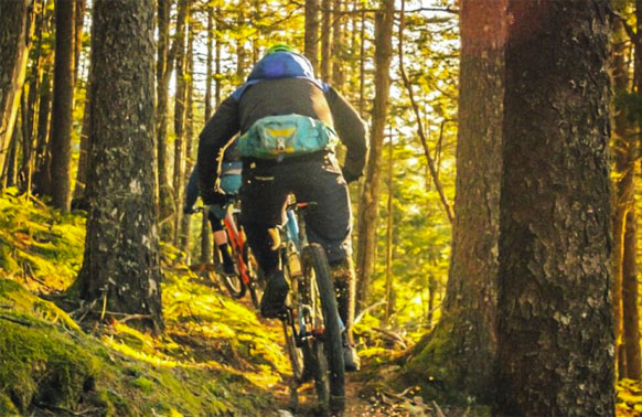
The Franklin Falls Dam federal flood control llands are located on both sides of the Pemigewasset River between Bristol and Franklin, NH. The property consists of more than 2,500 wooded acres and spans five towns. It is managed by the US Army Corps of Engineers. The mountain bike trail system is centered near the Franklin Falls Dam administrative offices on highway 127, three miles south of I-93 off exit 22. The system currently consists of approximately 10 miles of multi-use trail, built by mountain bikers for mountain bikers.
Much of the terrain is very “un-New England like” with very few rocks. As a result Franklin Falls is known for its flowing, buff single track. It is great venue for group rides with mixed skill levels. Experts can enjoy high speed tree-slaloming, while novices can enjoy the trails at a more relaxed pace without getting in over their heads in difficulty level. Even your roadie friends can have fun here! Some of the fastest flow can be found on trails that include Moose Gully, Pine Snake, Bee, Lost Wall Rusty Bucket, and Stump. Trails on the slightly tighter side include Rogue, Caddywhompus, and Cellar Hole. The newest trail, Sniper is a nice combination of flow and undulating terrain. For advanced riders looking for a more technical challenge, Salmon Brook Trail offers steeper pitches, tight switchbacks, narrow benches, bridges, and rock gardens. It rides best when entering at its intersection with the Rusty Bucket Trail.
The signature trail at Franklin Falls is Mighty Chicken. It is sure to put a smile on your face. Mighty Chicken is a gravity trail, built in a natural half-pipe created by the walls of Chicken Ravine. The trail surfs up and down the ravine walls then finishes out over a series of drops and berms. It continues to be tuned to increase the yeehaw! index.
The trail system is open year round, and is a great choice for early spring riding when other trail systems are closed for mud season. Sandy sub-soil keeps the area extremely well drained so mud is virtually non-existent.
Plymouth Trails
Pemigewasset Valley Mountain Bike Trails
19 Prince Haven Rd.
Plymouth New Hampshire 03264
United States
Description
Welcome to Plymouth – the gateway to the outdoor recreation in the western White Mountains of New Hampshire and the Lakes Region, you are a short trip away from world class hiking, skiing, biking, climbing and water sports.
Pemi Valley NEMBA has partnered with the Town of Plymouth, the Holderness Conservation Commission and the Oxbow Initiative to create great mountain biking opportunities with riding distance of downtown. For a more detailed map go to the Fox Park and Gyroscope Trail links on the Pemi Valley NEMBA Page.
Fox Park
The Trails: Fox Park’s singletrack trails are designed with intermediate riders in mind. These trails feature a great mix of flow and technical riding. You will encounter roots, rocks and steep terrain on these trails. For walkers, the doubletrack trails are most suitable.
Parking: the town of Plymouth has a large parking lot on Prince Haven Drive, off of Langdon Street. There is an informational kiosk and port-a-potty.
Gyroscope Trails
The Trails: The Pemigewasset Riverside Park, on the Holderness side of the river, has long been known to mountain bikers as the “Gyroscope Trails”, or “Gyro”. The trail network is unique in New Hampshire for its absence of rocks – making it a true beginner network. The winding and twisted single track is a great place to develop your turning skills.
Jump Area: The jump area contains advanced and expert features. Please use caution.
Getting There: Please park at Fox Park or the Plymouth Pump Track and ride across the river to get to Gyro. Railroad Square and Green Street provide a safe, low-traffic around Main Street, for bikers to get from the Pump Track to the bridge.
Pump Track
The Track: The pump track is a great place for beginners to develop their skills. There is a starting ramp and a figure-eight track of rollers and berms that winds its way through the old concrete supports, which also serve as a public graffiti canvas.
Laconia Trails
The WOW Trail, Laconia
The WOW Trail is a paved, 10 foot wide, multi-use pathway that parallels the existing RR corridor within the City of Laconia. Now 2.5 miles long, the trail travels from Elm Street in Lakeport to the Belmont Town Line. The trail connects to the new 1.7 mile Winnisquam Scenic Trail which leads to the Agway store on Rt. 3 near the Mosquito Bridge, giving users a 4 1/4 mile span to use. A portion of the WOW Trail veers out of the RR corridor, from Bisson Avenue to Lyford Street, in order to avoid the RR trestle over the Winnipesaukee River. Users will note a widened sidewalk with a dashed line down the middle in this section.
Well loved and well used by walkers, runners and bikers, the WOW Trail has become a unifying landmark and point of pride for the City of Laconia.
The WOW Trail now sets its sights on bringing the trail to the Weirs Beach area and on to Meredith.
Wolfeboro Trails
Wolfeboro Bike & Walking Trails
Albee Beach Lifeguards on duty 10am to 4pm mid June through end of August. This secluded and quiet beach offers swimming and picnicking on beautiful Lake Wentworth. Enjoy our 2 charcoal grills during the summer months (first come first served), relax at one of our many picnic tables or combine a trip to the beach with a bike ride on the Cotton Valley Trail. A favorite afternoon for many locals is to park at Albee Beach, ride bikes on the Cotton Valley Trail to downtown Wolfeboro for lunch or ice cream.
Bean Park
This “pocket park” in downtown Wolfeboro is a great place to stop and have a picnic, eat some ice cream, take rest on your bike ride along the Bridge Falls Path, or just sit and enjoy the views of Back Bay.
Bridge Falls Path
Come enjoy this ½ mile multi-use trail that connects to a regional network of multi-use trails. The Bridge Falls path provides a scenic walk, run or bike along the shores of Back Bay in between the Railroad Depot downtown to Wolfeboro Falls. After Crossing Route 28, it becomes the Cotton Valley Trail and continues on towards Albee Beach, Wakefield and beyond. Popular access points are at the Wolfeboro Railroad Depot, Albee Beach and Fernald Crossing.
Cotton Valley Trail
The Cotton Valley Trail connects with the Bridge Falls Path to provide multi-use rail trail access through Wolfeboro, along the shores of Crescent Lake and Lake Wentworth and onwards to Wakefield and beyond. Access points at Albee Beach, Mast Landing, Fernald Crossing and from the Bridge Falls Path.
Elie’s Woodland Walk
Located at Ryefield Marsh, Route 109 near Lake Wentworth. Self guided nature trail co-managed by the Conservation Commission and Parks and Recreation. This is a beautiful marsh that feeds into the north end of Lake Wentworth and is a great wildlife viewing area with herons, beaver activity, deer, moose and more. Located on Rt. 109 on the north end of Lake Wentworth.
Front Bay Conservation Area
Wooded parcel of land on Bay Street along the shores of what is now known as “Back Bay”, this area offers secluded paths, birding, wildlife viewing and picnicking. With a new trails system built in 2012, along with a picnic pavilion and a kayak/canoe landing, this is a great place to enjoy a quiet walk in one of Wolfeboro’s secret gems along the water. Park at parking area and walk 5-10 minutes down to water’s edge.
Northern Rail Trail
The Northern Recreational Rail Trail, also know as the Northern Rail Trail, is a 58-mile (93 km) multi-use trail in western New Hampshire running from Lebanon to Boscawen. It uses the right-of-way of the Boston and Maine Railroad’s former Northern Line, which was acquired by the state of New Hampshire in 1996. The trail is managed by the New Hampshire Bureau of Trails.
Northern Rail Trail is a 48.8 mile moderately trafficked point-to-point trail located near Lebanon, New Hampshire that features a lake and is rated as moderate. The trail offers a number of activity options and is best used from March until November. Dogs are also able to use this trail but must be kept on leash.
The Northern Rail Trail follows the route of the Boston & Maine Railroad as it winds its way along the Mascoma River. The Northern Rail-Trail is one of the most family friendly trails in New Hampshire. The trail starts in Lebanon and is a pleasant jaunt to Danbury. While many rail-trails follow rivers along their course, the Northern gives riders a chance to get up close and personal with the Mascoma River as the trail crosses the river seven times within the first four miles. The trail starts at the Witherell Recreation Center in Lebanon and is obviously a family favorite. Tagalongs, tandems, trailers, and training wheels dominate the first couple miles of the trail as children and their parents enjoy this beautiful stretch of the trail that takes full advantage of old railroad bridges to cross the river about every half mile or so. Gradually the trail population begins to thin out.
Trail end Points: Spencer Street (Lebanon) and River Road near Hannah Dustin Park & Ride (Boscawen)
Parking and Trail Access
In Grafton County, parking is available at the following places:
To reach the Lebanon trailhead near the Lebanon College campus, take I-89 to Exit 18 and head south on SR120 toward Lebanon. The trailhead is at the intersection of Taylor and Spencer streets. If the trailhead parking lot is full, street parking is available.
To reach the Grafton trailhead, take SR 4 east into town. Trail access lies opposite the general store. Park in the dirt pullout on the trail side of the highway.
Additional trailhead parking is available along Main Street off SR 4 in Enfield and at the end of Depot Street off Route 4 in Canaan.
In Merrimack County, parking is available at the following places:
- At the southern end of the trail, opposite the State Nursery on Route 3 in Boscawen.
- In the public lot across the street from the Congregational Christian Church (25 South Main Street) in West Franklin. Access from the lot is by crossing Route 3 and going to the west end of the parking lot behind the church and walking your bike up the short steep hill to the trail. Alternatively, you can drive just a bit farther south on Route 3 to a right turn on Depot Street; drive a short distance and take swinging left after a few yards, then turn right through an underpass and then left on Wells Street, where you will see an entrance to the trail immediately on your left.
- In the public lot at Webster Lake in Franklin at the intersection of NH Route 11 and Webster Avenue. Access is across NH Route 11 at Chance Pond Road.
- At the Highland Lake Inn parking lot (32 Maple Street) in East Andover. Access is down Maple Street about 150 feet to the trail.
- At Blackwater Park at the intersection of Lawrence Street and Park Street. Access is at the park.
- At the restored railroad station at Potter Place in Andover. Access is at the station or at the northwest edge of the large parking lot north of the station.
- In the center of Danbury at the intersection of US Route 4 and NH Route 104. Access and parking are on the west side of US Route 4 alongside the trail and just north of the intersection of Route 4 and NH Route 104.
- At the Hannah Dustin Park & Ride on Route 4, which is about a mile west of I93 at exit 17. Access is down the ramp marked with the Hannah Dustin sign; turn right at the bottom, cross the RR tracks, turn right again. You are now on River Road. Go about a half mile north on River Road and on your right will be the start of the trail.
Concord Trails
I-89 Bike Path
This ride’s general location is southwest of Concord. The bike trail is 2.4 miles long and easy for riders of all ages. Scenery includes mixed fields and woods. This is a good family ride; do not miss the New Hampshire Audubon Center. A short paved bike path in the suburbs? Yes, and the path has some great things going for it. It’s just outside the city of Concord, so it’s convenient. It’s beyond the developed areas, and the meadows and woods along the trail are quite pretty. The ride includes a separate bridge over Turkey Pond with a great view. The Audubon Center sits a few hundred feet away from the trailhead and has educational exhibits, a simulated ecosystem, and a gift shop. Two hiking trails take you out to prime birdwatching locations around Turkey Pond. Kids will love this ride.
For more Trails throughout New Hampshire go to NEMBA for a complete list of trails, maps, directions, information on the trails, terrain and the distance of the trails.
www.nemba.org/trails/new-hampshire